Welcome to the second lesson in module 2.
In the previous lesson, we selected the basic_sr_hdf5 asset from list of available options. This lesson explains what each asset represents and helps you understand how to choose the best one for your task.
Before we define each asset, we’ll refresh your remote sensing background through answering two core questions:
What does the pixel value represent physically? (radiance vs. surface reflectance)
Where is that pixel located geometrically? (image-space vs. map-space / ortho)
Planet delivers Tanager imagery as Basic or Ortho scenes, and as Radiance or Surface Reflectance, with a “visual” preview and quality masks available as additional assets. You can use Figure 1 as a reference to identify each asset’s properties.
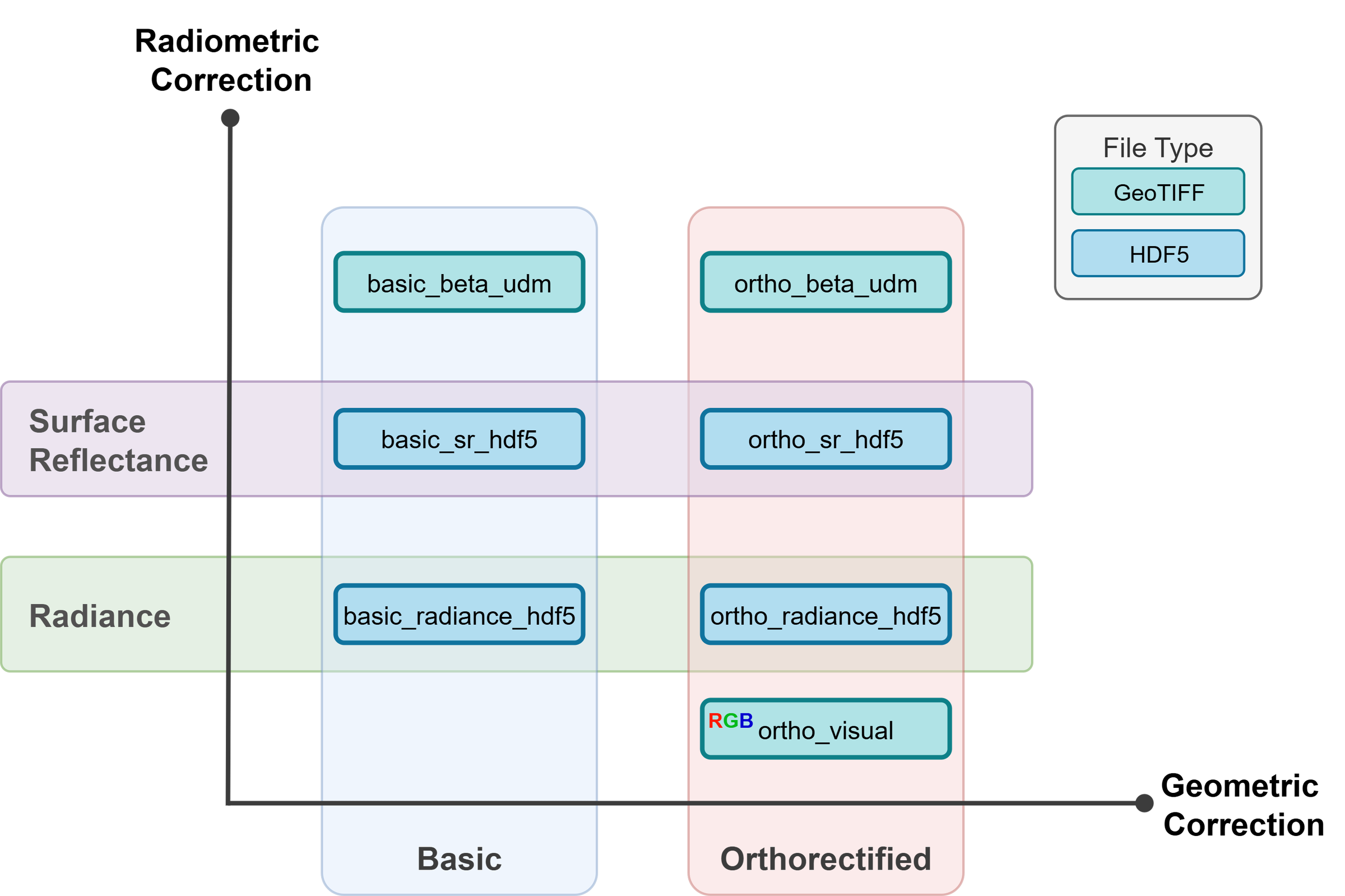
Figure 1:Tanager-1 assets by geometry (Basic vs Ortho) and physics (Radiance vs Surface Reflectance).
The Physics: Radiometric Correction
Radiance (calibrated measurements of energy by the sensor)
Radiance represents the quantitative measure of light energy reaching the satellite, often termed Top-of-Atmosphere (TOA) radiance. This product is derived by converting raw Digital Numbers (DN) recorded by the sensor into standardized physical units (). As an “at-sensor” measurement, radiance accounts for the instrument’s specific response but includes the full effects of the atmosphere. The signal is a composite of surface-reflected sunlight and path radiance (light scattered by the atmosphere directly into the optics). Because it measures absolute energy, the values are inherently influenced by solar geometry and atmospheric conditions at the moment of acquisition.
Surface Reflectance (the proportion of reflected light from the surface)
Surface Reflectance, or Bottom-of-Atmosphere (BOA) reflectance, is an atmospherically corrected estimate of the surface’s actual reflective properties. By removing atmospheric effects—like haze, aerosols, and water vapor, we isolate the intrinsic properties of the materials on the ground. Unlike radiance, surface reflectance is a unitless ratio (ranging from 0 to 1, or 0% to 100%) representing the fraction of incoming sunlight reflected by the surface.
The Geometry: Basic vs. Ortho
Tanager assets come in two geometry “families”:
Basic = image-space (sensor geometry)
Basic products are unorthorectified and not mapped to a cartographic projection. Think “pixels as the sensor saw them.”
However, Tanager assets include a separate geolocation array (lat/lon per pixel) intended for users who want to do their own mapping/orthorectification.
Ortho = map-space (cartographic geometry)
Ortho products are orthorectified and projected to a cartographic map projection, with terrain distortions removed using Digital Elevation Models (DEMs).
Decoding the Asset Names
Most names follow a consistent pattern:
basic_...= Basic (image-space, georeferenced, but not map-projected)ortho_...= Ortho (orthorectified + projected)...radiance...= top-of-atmosphere radiance (pre-atmospheric correction)...sr...= surface reflectance (after atmospheric correction)...hdf5= hyperspectral cube in HDF5 (native format for Tanager hyperspectral products)...udm= usable data mask (quality mask; clouds, etc.)geolocation_array= per-pixel lat/lon array for Basic scenesortho_visual= quick-look RGB “natural color” view for context (human interpretation / reporting).
Asset Summary Table
Use this table to decide which file matches your analysis needs.
| Asset Name | File Format | Geometry (Shape) | Content (Physics) | Best For... |
|---|---|---|---|---|
basic_sr_hdf5 | HDF5 | Sensor / image-space | Surface Reflectance | Advanced workflows. You want SR but will handle mapping yourself using the geolocation_array. |
basic_radiance_hdf5 | HDF5 | Sensor / image-space | Radiance | Atmospheric / method development. You want the raw TOA signal to run your own atmospheric correction. |
basic_beta_udm | GeoTIFF | Sensor / image-space | Data mask | Quality control. Masking clouds/invalid pixels for Basic assets. |
geolocation_array | GeoTIFF | Sensor / image-space | Coordinates | Navigation. Required to map Basic pixels to lat/lon (and to warp to a projection). |
ortho_sr_hdf5 | HDF5 | Map / Ortho | Surface Reflectance | Orthoprojected hyperspectral SR cube ready for analysis: mapping, indices, classification, and time series (no manual geolocation/warping). |
ortho_radiance_hdf5 | HDF5 | Map / Ortho | Radiance | Radiance projected to a map grid. Useful for QA, comparisons, or workflows using TOA radiance but in map geometry. |
ortho_beta_udm | GeoTIFF | Map / Ortho | Data mask | Quality control. Masking clouds/invalid pixels for Ortho assets. |
ortho_visual | GeoTIFF | Map / Ortho | RGB image | Context + reporting. Fast preview for humans (not for quantitative hyperspectral analysis). |
The Naming Convention: Reading the Label
Before we continue our lessons, we need to understand the filename of Tanager-1.
Every Tanager-1 filename is a precise timestamp and origin identifier. Understanding this structure allows you to sort an image instantly without opening it.
The Anatomy of a Filename
20241006_154116_92_4001_ortho_radiance_hdf5.h5
| Segment | Value | Meaning |
|---|---|---|
| Date | 20241006 | October 6, 2024 (YYYYMMDD) |
| Time | 154116 | 15:41:16 UTC (HHMMSS) |
| Fraction | 92 | 0.92 Seconds (Hundredths of a second) |
| Sat ID | 4001 | Tanager-1 (The specific satellite ID) |
| Asset | ortho_... | The Product Type (Geometry + Physics + Format) |
Summary & Next Steps
You now understand the Tanager-1 asset ecosystem: the difference between Basic and Ortho geometry, between Radiance and Surface Reflectance, and how to decode filenames. With this knowledge, you can confidently select the right asset for your analysis goals.
Next Up: In Lesson 3 of Module 2, we’ll practically work with Basic and Ortho assets side-by-side to see how geometry changes between the raw sensor view and the map-projected view.
See you in Lesson 3 of Module 2: Basic vs Ortho!